 |
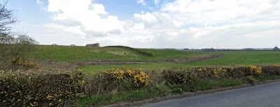
| View of greenbelt land from Whitfield Lane in Barnston. |
Applications are currently being consulted on for 7 'screening opinions and scoping requests’ submitted by Leverhulme Estates for
building houses on Green Belt land in Wirral. NOTE, these are not planning
applications (they will come next) but applications to agree with the local
authority on what environmental issues and studies are needed to be done before
outline planning permission can be applied for. This is purely about
environment (in the broad term including heritage) and is not the place to
question housing `need’ numbers.
Our concerns are those below, which anyone is welcome to
quote in their own comments on the applications.
Links to comment on the applications are below, or you can email planningapplications@wirral.gov.uk
quoting the reference number.
The closing date to submit your comments is Saturday 29th January 2022.
Concerns relating to all sites
- The Environmental Impact Assessment (EIA) must consider the cumulative impact of these 7-8
proposals on the environment of Wirral, including on biodiversity. Table 6
omits several planning applications in progress for large amounts of housing,
especially in Bromborough/Eastham.
- The EIA should examine whether there are any environmental `very
special circumstances’ for or against building on this Green Belt and
greenfield land.
- The EIA must include impacts on all SBIs neighbouring the
site. The current documents omit Harrock Wood (21/02384 Irby) and for the two
Raby Hall, Raby Mere (21/02383 and 21/02386) omit Plymyard Dale and Bromborough
Golf Course. The EIA must include impacts of supplying services to the land (Raby Mere in
particular).
- The EIA must cover suitable hydrological studies to ensure
neighbouring ponds are not drained by falling water tables (Irby and Raby Mere).
- The EIA must consider buffer zones needed to all the SBIs
and Priority Habitats.
- The EIA must consider ecological networks and the risks of
breaking these (Irby).
Items that should be scoped in, not out
Climate change - Greenfield land, even under intensive
agriculture, emits little carbon. Houses and their associated transport emit far
more. Ask for a well-respected carbon
calculator to be used e.g. as used by the Environment Agency.
Drainage in relation to ponds and water tables (Irby and Raby
Mere), and the effects on watercourses (Irby for Arrowe Brook, Raby Mere for
River Dibbin, Barnston for Prenton Brook.)
Lighting - These are all relatively dark areas where
lights will impact wildlife such as invertebrates, bats.
Further ecological surveys needed
- Breeding birds, including farmland birds and barn owls (Irby,
Raby Mere, Barnston).
- Great Crested Newts as already detected: Raby Mere, Irby.
- Water voles as there are reports from Arrowe Brook area and
Dibbinsdale (Irby, Raby Mere). Otter can be checked in the survey, though risks
are low.
Concerns for specific sites
Ecological networks, drainage to brook and of
pond network, surveys needed for breeding birds, great crested newts, water
voles. Include impacts on Harrock Wood and buffer zone to Arrowe Park. Wayleave
for HVDC Western Link cables.
- 21/02383 and 21/02386 by Raby Hall, Raby Mere
Surveys for
breeding birds, great crested newts, water voles. Drainage impacts on Dibbin
and on pond network.
- 21/92377 Barnston Road Heswall
Breeding birds including
farmland.
- 21/021379, 21/02381, 21/02385 all north of Gills Lane,
Barnston
Drainage impacts on Prenton Brook, erosion problems in Barnstondale
(where existing erosion whenever the reservoirs are cleaned), more surveys for badgers,
breeding birds. Effects on ecological networks.
Links to Screening Opinion and Scoping Request Documents
Please submit your comments by following the links listed below.
- Land East of Dale View Close, North of Gills lane Pensby –
up to 100 houses.
SCR/21/02385
https://planning.wirral.gov.uk/online-applications/applicationDetails.do?activeTab=documents&keyVal=_WIRRA_DCAPR_112773
- Land East of Thorncroft Drive, North of Gills Lane, Pensby.
– up to 15 houses.
SCR/21/02381
https://planning.wirral.gov.uk/online-applications/applicationDetails.do?activeTab=documents&keyVal=_WIRRA_DCAPR_112769
- Land west of Barnston Road, North Of Gills Lane – up to 160
houses.
SCR/21/02379
https://planning.wirral.gov.uk/online-applications/applicationDetails.do?activeTab=documents&keyVal=_WIRRA_DCAPR_112767
- Land east of Glenwood Drive, Irby. Up to 310 houses.
SCR/21/02384
https://planning.wirral.gov.uk/online-applications/applicationDetails.do?activeTab=makeComment&keyVal=_WIRRA_DCAPR_112772
- Land east of Raby Hall, Raby Mere. 85 houses.
SCR/21/02383
https://planning.wirral.gov.uk/online-applications/applicationDetails.do?activeTab=makeComment&keyVal=_WIRRA_DCAPR_112771
- Land west of Raby Hall, Raby Mere. 40 houses.
SCR/21/02386
https://planning.wirral.gov.uk/online-applications/applicationDetails.do?activeTab=makeComment&keyVal=_WIRRA_DCAPR_112774
- Land at Milner Road/Barnston Road Heswall. 120 houses
SCR/21/02377
https://planning.wirral.gov.uk/online-applications/applicationDetails.do?activeTab=makeComment&keyVal=_WIRRA_DCAPR_112765


